FAQ
MasterPlanner™ is the answer to common questions posed by MicroStation CONNECT users …
Q
- What is an Area Feature?
- How do I measure an area and have that measurement updated automatically?
- How can I calculate bulding density?
- How can I obtain reports of area measurements?
- How can I create a table of area measurements?
- How can I annotate and report on multiple objects?
- How can I search for an element that has a certain property value?
- What happens to my annotation when I modify an area?
- Can I label an area using a different metric?
- What happens if I delete a label?
- How can I align annotations?
- How do I obtain MasterPlanner?
MasterPlanner™ works with technology introduced with MicroStation CONNECT to annotate and update object measurements. See the notes about MicroStation Version for more detail.
Area Feature
An Area Feature is a DGN shape or complex shape element that you have tagged with Item Type properties using MasterPlanner's tools. Depending on your location in the world, your synonym for an Area Feature might be Lot or Land Parcel. You can manipulate and query an Area Feature using MicroStation and MasterPlanner tools. You can create a worksheet using FlexiTable™ or write a Report using MicroStation tools.
Area Measurements
MasterPlanner CONNECT Edition is a development of an annotation tool for a previous generation of MicroStation (MicroStation V8i). It lets you annotate an area feature, such as a shape or complex shape element. More exactly, MasterPlannern works with planar closed shapes in a 2D or 3D DGN model. MasterPlanner uses MicroStation Text Fields to create smart labels. MicroStation observes changes to the area and updates the shape's annotation label automatically.
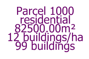
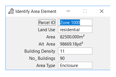
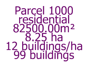
In the example above, you can see the following labels created by MasterPlanner …
- Parcel 1000 is the user-assigned ID. It's created from the MasterPlanner ID property
- Residential is the user-assigned purpose. It's created from an MasterPlanner purpose property
- 82,500m2 is the shape's area. It's created from the shape's Area property. The area label is a text field and updates automatically if you modify the shape it references.
Building Density
The Building Density property expresses the number of building per unit area. MasterPlanner calculate the number of buildings per plot (or area) by multiplying the plot area by the building density. That calculation is automatic: if you modify the DGN element and change its area, then the number of buildings is updated.
Search Tool
MasterPlanner has a search tool …
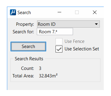
See the Search page for more information.
Align Annotation Labels
MasterPlanner has an align tool. When you attach area properties to an element you can place the label manually wherever you want. Subsequently you may want to realign the labels for neatness. The align tool lets you place multiple labels, each relative to its host, in a uniform manner.
See the Alignment page for more information.
Using Alternative Metrics
By 'Alternative Metrics' we mean the ability to label an area using both the DGN model master units (e.g. feet²) and an alternative unit (e.g. metres²). MasterPlanner lets you choose to use an alternative metric in addition to the default DGN model master unit. Here's an example …
MasterPlanner Item Properties
MasterPlanner uses a MicroStation Item Type schema definition named Area Feature. MasterPlanner uses several user-supplied properties from its MicroStation Area Feature schema to annotate an object …
MasterPlanner also uses several non-editable properties from its MicroStation Area Feature schema to format alternative measurements, if enabled …
- Alternative Area units (e.g.
acresorhectares)
Non-editable property values are calculated automatically by MasterPlanner. If you have chosen to use them, you will see alternative measurement in the labels & reports created by MasterPlanner.
Room ID
MasterPlanner helps you to annotate room IDs drawn as MicroStation shape or complex shape elements.
If you are annotating site plots or parcels
you may want a consistently-numbered parcel ID. For example, parcel numbering in your current model may start
with parcel 100 and continue in increments of five.
What's more, you can add explanatory text around the ID,
so your sequence would look something like
Parcel 100, Parcel 105, …, Parcel 125, Parcel 130.
The ID is invaluable when creating a report or table. The ID provides a visual reference to the tagged object.
Auto Increment
MasterPlanner will auto-increment the Parcel ID as you annotate area features. In the Settings dialog, you control (a) whether you want to enable auto-increment and (b) the amount by which the ID is incremented (the delta value).
Area Type
You can designate an area to represent an Enclosure or a Void.
For example, a zone might be tagged as an Commercial. Shapes within that hall might be tagged as Entertainment. An external report or calculation could evaluate the net area of the commercial area as its area less the area of all entertainment.
Area Type Picklist
When you install MasterPlanner it automatically creates a Pick List named Area Type that is associated with property Area Type. You can modify that Pick List using MicroStation's Pick List Manager.
Land Use
MasterPlanner lets you select a value for the Land Use property from a pick list.
You can use MicroStation Display Rules with the Land Use property to modify the way in which MicroStation displays parcels. Read more about Display Rules.
Purpose
MasterPlanner helps you to explain the purpose of an object. If you are annotating rooms you may want to describe parcels as commercial space, residential, business etc.. MasterPlanner's Purpose tag lets you assign a purpose to an object.
The Purpose is invaluable when creating a report or table. The Purpose property provides a way to classify similar types of object, and filter and sort reports.
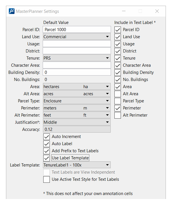
The screenshot above shows MasterPlanner's Tool Settings for Labelling. The text fields show the values assigned to the target area. The toggle buttons let you choose to include or omit data from the labels you create. For example, you might choose to show just the ID, or perhaps the ID and the Area.
Purpose Picklist
When you install MasterPlanner it automatically creates a Picklist named Purpose that is associated with property Purpose. You can modify that Picklist using MicroStation's tools.
Label Template
MasterPlanner labels a parcel with either of two types of label …
- A text label that shows the Item Type formatted values
- A label template that contains additional text and graphics as well as the Item Type formatted values. See the Annotator Labels page
What Happens if I Delete a Label?
With MasterPlanner a label is just a label. It reflects the underlying Item Data attached to a DGN element.
If you delete a label, the Item Data remains attached to the DGN element. If you use MasterPlanner's tag command, the Item Data is once more visible in the new label.
How do I delete Item data?
If you want to remove the Item data that underpins an MasterPlanner label, then use the AREA TAG REMOVE command.
When you remove the Item data, MasterPlanner automatically deletes its label,
Automatic Update
The annotation labels you create with MasterPlanner update themselves when you modify the host shape. That is, when you use one of MicroStation's built-in tools to edit or modify a labelled shape, you see the new measurement displayed automatically in the label.
MasterPlanner Reports & Tables
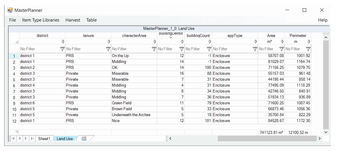
MasterPlanner delegates reports & table creating to FlexiTable™.
You can also use MicroStation's built-in tools to create reports and tables. From a Report, you can create a table for placement as a DGN graphic element. To create a table from a Report, use the tools that MicroStation provides.
Annotating Multiple Objects
MasterPlanner™ CONNECT Edition includes a tool to tag multiple objects with the MasterPlanner Item Types. The bulk tagging tool searches a DGN model for shapes on a named level. When it tags a shape, MasterPlanner creates a label to provide a visual clue that the element is annotated.
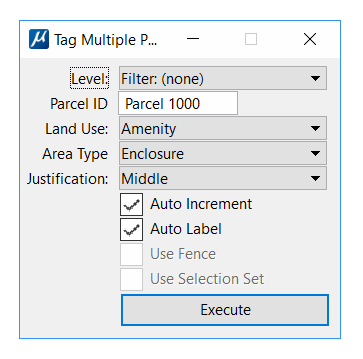
The MasterPlanner ID, which is visible in the label, is auto-incremented for each shape. For example, if your ID takes the form Parcel 101, then subsequent labels will be Parcel 102, Parcel 103, Parcel 104 …etc.
MasterPlanner Settings
MasterPlanner settings are described here.
Download MasterPlanner
Visit the download page to register your interest in MasterPlanner and download the installer.
About MicroStation
MicroStation®, created by Bentley Systems, helps you to design, analyse, and present 3D models and 2D designs. MicroStation stores your models and designs in a DGN file.
